Maps, Media and Manipulation
summary
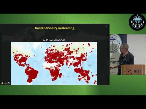
Maps and media actively shape politics: propaganda maps from WWI and US Civil War deliberately stoke fear, Cold War GPU/KGB techniques invent black propaganda, modern state maps shift borders (China’s new 10‑dash line dispute) and corporate edits rename the Persian/Arabian Gulf for politics. Common mistakes include county COVID maps using absolute counts instead of cases per 100k, sensational “Earth on fire” hotspot visuals, and GAN‑made fake satellite imagery that passes casual inspection; studies report ~70% higher sharing of emotionally charged false items.
AI-written summary · about
chapters (10)
- 0:00Introduction to maps and media
- 3:13Maps as propaganda tools
- 6:27Evolution of disinformation in maps
- 9:21Unintentional misleading examples
- 12:51Government and political map manipulation
- 15:24Naming conventions and geopolitics
- 16:49How misinformation spreads fast
- 18:17Real-life examples of deception
- 19:03AI threat to map authenticity
- 20:28How to spot and resist manipulation
related talks
 49mThe Untruthful Art - Five Ways of Misrepresenting Data
 51mThe Untruthful Art - Five Ways of Misrepresenting Data
 56mThe Untruthful Art: Five ways of misrepresenting Data
 48mHow We Lie to Ourselves With Charts
 35mDisinform your Surroundings: AI and disinformation campaigns
 29mRecent Trends in Information Operations and Predictions for 2020
 35mBad Charts
 40mHot Topics in Misinformation: Election 2020, COVID 19, and More