Watching Millions of Trees with Python: For Impact and Profit

summary
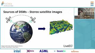
Claim: machine learning on high‑resolution satellite imagery monitors millions of trees worldwide and surfaces actionable alerts. Evidence: 100,000 labeled trees and petabytes of unlabeled imagery, using 30 cm resolution imagery, self‑supervised and active‑learning workflows that cut labeling needs, stereoscopic methods giving tree height accuracy <1 m, and a shipped dashboard for utilities preventing power‑line fires tied to an API and production stack (fastai PyTorch nbdev Redis Airflow). Watch if these are the specifics wanted.
AI-written summary · about
chapters (17)
- 0:00Introduction
- 3:17Why forests matter
- 7:57Forestry pitfalls
- 10:01Forest fires from space
- 13:09Petabytes with Python
- 15:59AI for forest monitoring
- 17:22Unsupervised learning
- 18:243D mapping
- 20:30Active learning
- 22:15FastAI and PyTorch
- 23:19FastAI callbacks
- 25:25Type annotations
- 26:48Debugging AI models
- 28:13Notebooks to production
- 30:43Power line vegetation maps
- 31:44Resources and communities
- 32:46Q&A
related talks
 27mSmart Forestry: AI in the Service of Nature
 41mAbby Seneor | AI Track | Compass AI & Data Summit 2025
 28mGeoAI: Evolution of AI-Based Tree/Vegetation Detection Models Using Imagery
 48mTaking the planet’s pulse: AI to empower adaptation to global change
 30m🌳 The taller the tree, the harder the fall. Determining tree height from space..
 30mUsing AI to Spot Deforestation-related Cows on Satellite Images
 58mImproving disaster response with machine learning
 32mMeasuring Vegetation Health to Predict Natural Hazards